
RECOGNIZING HIGH ICE CRYSTAL CONDITIONS
Researchers have identified several conditions that are connected to engine ice crystal icing events. The most important factors are:
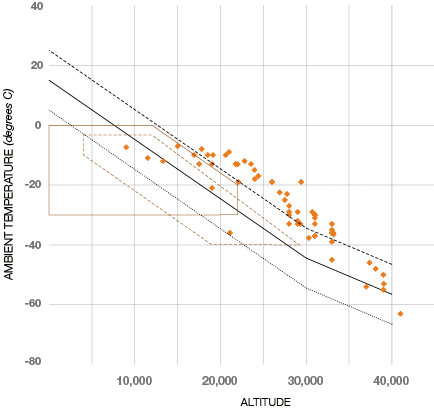
- High altitudes and cold temperatures. Commercial airplane power-loss events associated with ice crystals have occurred at altitudes of 9,000 to 39,000 feet, with a median of 26,800 feet, and at ambient temperatures of -5 to -55 degrees C with a median of -27 degrees C. The engine power-loss events generally occur on days when the ambient temperature is warmer than the standard atmosphere (see fig. 4).
- The presence of convective clouds. Convective weather of all sizes, from isolated cumulonimbus or thunderstorms to squall lines and tropical storms, can contain ice crystals. Convective clouds can contain deep updraft cores that can lift high concentrations of water thousands of feet into the atmosphere, during which water vapor is continually condensed and frozen as the temperature drops. In doing so, these updraft cores may produce localized regions of high ice water content which spread downwind. Researchers believe these clouds can contain up to 8 grams per cubic meter of ice water content; by contrast, the design standard for supercooled liquid water for engines is 2 grams per cubic meter.
Click the image above to view a unique time-lapse video of thunderstorms building and decaying over the Alps. - Areas of visible moisture above the altitudes typically associated with icing conditions. This is indicated by an absence of significant airframe icing and the ice detector (when installed) not detecting ice, due to its ability to detect only supercooled liquid, not ice crystals.
Figure 4
Temperatures for the majority of the events for which data is available are significantly warmer than standard day temperatures, and also fall outside of the current icing design envelopes for supercooled liquid water.
|
 |


- No pilot reports of weather radar returns at the event location.
- Temperature significantly warmer than standard atmosphere.
- Light-to-moderate turbulence.
- Areas of heavy rain below the freezing level.
- The appearance of precipitation on heated windshield, often reported as rain, due to tiny ice crystals melting.
- Airplane total air temperature (TAT) anomaly-reading zero, or in error, due to ice crystal buildup at the sensing element (see case study on following page).
- Lack of observations of significant airframe icing.
RECOMMENDATIONS FOR FLIGHT NEAR CONVECTION
Even when there are no radar returns, there may be significant moisture in the form of ice crystals at high altitudes. These are not visible to airborne radar. As a result, it is not possible to avoid all ice crystal conditions. However, normal thunderstorm avoidance procedures may help pilots avoid regions of high ice crystal content.
These avoidance procedures include:- Avoiding flying in visible moisture over storm cells. Visible moisture at high altitude must be considered a threat since intense storm cells may produce high concentrations of ice crystals at cruise altitude.
- Flying upwind of storms when possible.
- Using the radar antenna tilt function to scan the reflectivity of storms ahead. Assess the height of the storms. Recognize that heavy rain below the freezing level typically indicates high concentrations of ice crystals above.
- Avoiding storm reflectivity by 20 nautical miles has been commonly used as a recommended distance from convection. This may not be sufficient for avoidance of high concentrations of ice crystals, as they are not visible on airborne radar.
These recommendations are included in flight operations technical bulletins Nos. 707-06-1, 727-06-1, 737-06-1, 747-15, 747-400-55, 757-75, 767-75, 777-21, 787-1 issued by Boeing on August 1, 2006: Convective Weather Containing Ice Crystals Associated with Engine Power Loss and Damage.
